
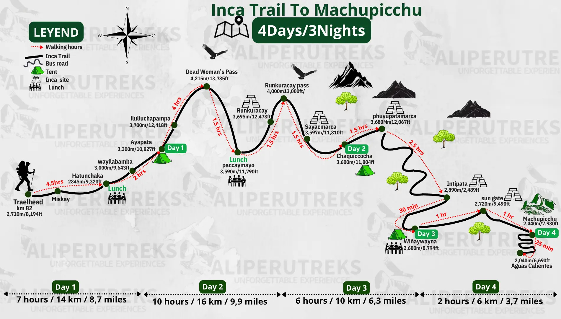
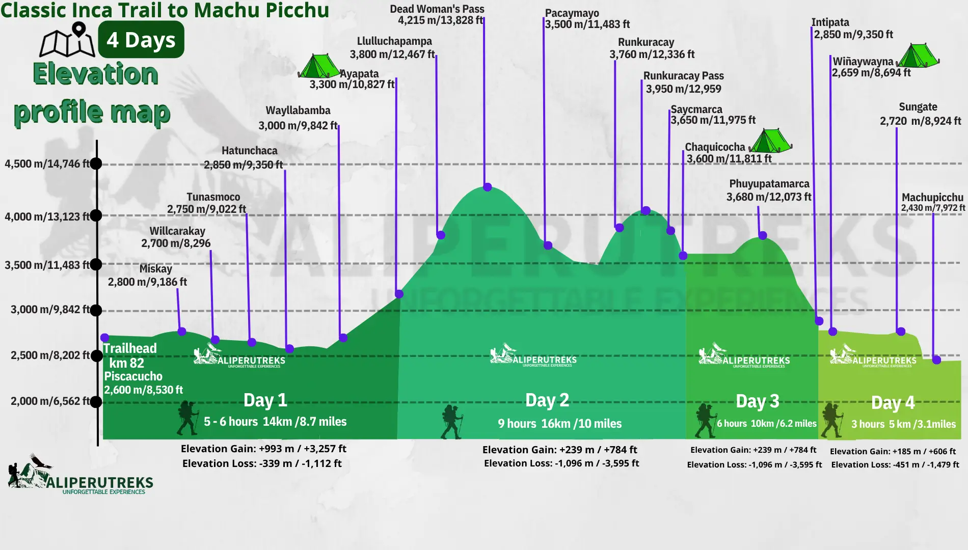
The classic Inca Trail itinerary is a 4-day, 3-night trek of roughly 42–43 km (26 miles) that starts at Km 82 in the Sacred Valley and ends at Machu Picchu via the Sun Gate. Day 2 is the hardest, crossing Dead Woman’s Pass at 4,215 m (13,828 ft). Days 3 and 4 are mostly downhill through cloud forest, with Inca ruins along the way.
Below is what each day involves, with distances, hiking times, and altitudes, plus the parts of the itinerary that surprise first-timers.
Inca Trail Itinerary at a Glance
| Day | Route | Approx. distance | Hiking time | Key altitude |
|---|---|---|---|---|
| 1 | Cusco – Km 82 – Llactapata – Wayllabamba | 12–14 km (7.5–8.7 mi) | 6–7 hours | Km 82: 2,600 m; Wayllabamba: 3,000 m |
| 2 | Wayllabamba – Dead Woman’s Pass – Pacaymayo | 11–16 km (7–10 mi) | 7–10 hours | Pass: 4,215 m (13,828 ft) |
| 3 | Pacaymayo – Runkurakay – Sayacmarca – Phuyupatamarca – Wiñay Wayna | 10–16 km (6–10 mi) | 6–9 hours | Runkurakay: 3,950 m; Wiñay Wayna: 2,650 m |
| 4 | Wiñay Wayna – Sun Gate – Machu Picchu – return to Cusco | 5–6 km (3–4 mi) to the citadel | About 2 hours, then a guided tour | Machu Picchu: 2,430 m (7,972 ft) |
Distances differ between operators because campsites vary and each measures the trail slightly differently. Ali Peru Treks’ published itinerary lists 14 km for Day 1 and 16 km for Day 2, while other operators list Day 2 as short as 11 km. Total distance clusters around 42–43 km whichever way it is counted.
Day 1: Cusco to Km 82 and Wayllabamba
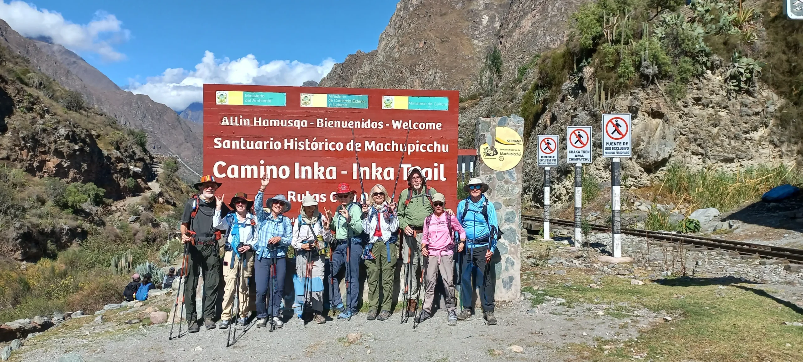
The day starts early with a transfer from Cusco to the Km 82 trailhead (also called Piscacucho), usually with a breakfast stop in Ollantaytambo. At the checkpoint your guide presents your permits and you show your original passport. Your porters take your duffel while you carry a small daypack.
The trail crosses the Urubamba River and follows the valley on gently rolling terrain. You pass the Inca site of Llactapata (also spelled Patallacta), with views toward the snow-capped Verónica massif. The walk ends near Wayllabamba (3,000 m / 9,842 ft), the last village on the route, where you can buy snacks and drinks. Camp is in the Wayllabamba/Ayapata area, depending on the operator.
Honest take: Day 1 is described as the easy day, and by distance it is. But you are already close to 3,000 m, so people coming straight from sea level often feel it. If that sounds like you, read up on altitude sickness in Cusco before you travel.
Day 2: Dead Woman’s Pass
This is the day that decides how the trek feels. From Wayllabamba the trail climbs steadily for several hours to Warmiwañusca, known as Dead Woman’s Pass, at 4,215 m (13,828 ft). It is the highest point of the trek. After a rest at the summit, you descend into the Pacaymayu valley for lunch, then climb again toward the Runkurakay ruins before descending to camp at Pacaymayo.
Total time on your feet is typically 7–10 hours depending on your pace. There are no technical sections. The difficulty is sustained uphill walking in thin air, followed by a long knee-punishing descent on stone steps.
Honest take: Trekkers usually say Day 2 is harder than they expected, and the altitude matters more than fitness. Going slowly and stopping often helps more than pushing.
Day 3: Ruins and Cloud Forest
Day 3 is the most scenic and usually the longest in distance. You climb to Runkurakay Pass (3,950 m), then pass Sayacmarca, an Inca settlement on a ridge, and continue through a short Inca tunnel. Phuyupatamarca (3,650 m), often called the “town above the clouds,” comes next, followed by a long stone staircase descent through cloud forest to Wiñay Wayna (2,650 m).
The last campsite sits close to the Wiñay Wayna terraces, which are visited in the afternoon. The name means “forever young” in Quechua. Many operators also stop at Intipata, a set of agricultural terraces just before camp.
Honest take: The descent is hard on the knees, so trekking poles help. This is also the best day for orchids and birds, since the trail drops into cloud forest.
Day 4: Sun Gate and Machu Picchu
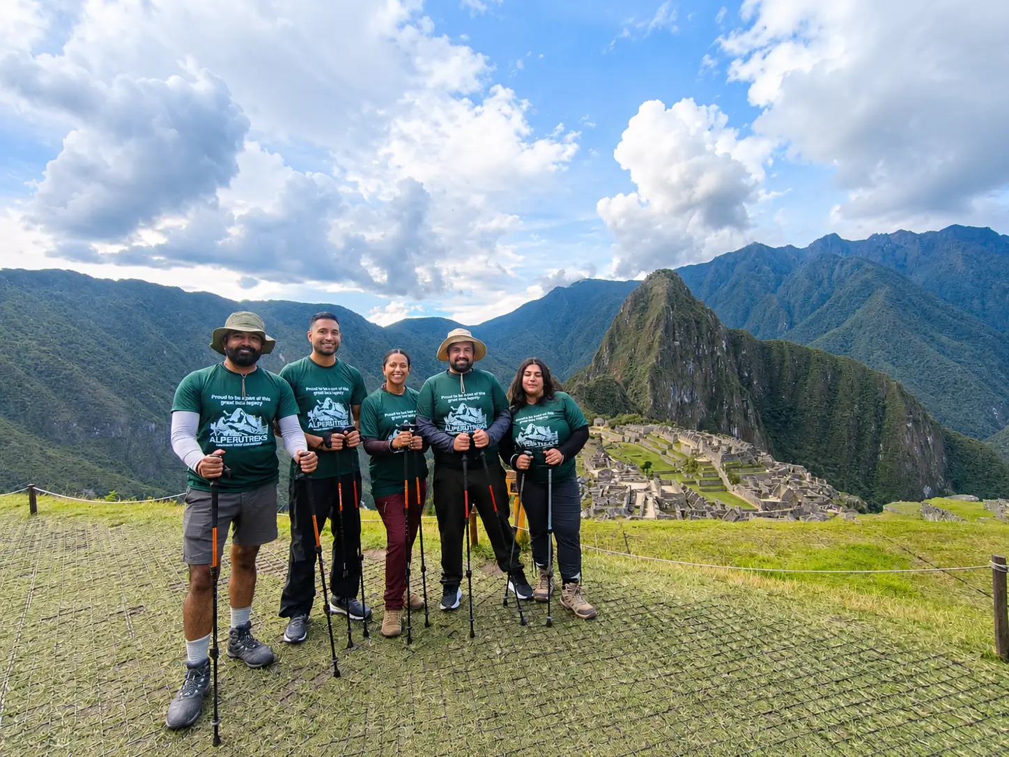
Day 4 starts very early. The checkpoint below Wiñay Wayna opens around 5:30 a.m., so camps typically wake groups before dawn. The walk to Inti Punku (the Sun Gate) takes about an hour, including a steep final staircase. From the Sun Gate you get your first view of Machu Picchu, then descend for roughly another hour into the citadel for a guided visit. After that, most itineraries continue by bus to Aguas Calientes and by train back toward Cusco.
Honest take: The arrival at the Sun Gate is the highlight for many trekkers, but clouds sometimes block the view, and you should not count on a clear sunrise. Also note that since the permit rules changed, the Inca Trail permit no longer includes the Machu Picchu entrance ticket, which is now a separate timed ticket that your operator arranges. See the new Machu Picchu circuits guide for how the circuits work.
How Other Inca Trail Itineraries Differ
Not everyone wants the standard 4 days. These are the main variations:
| Version | Duration | What changes |
|---|---|---|
| Classic Inca Trail | 4 days / 3 nights | The standard route described above |
| Inca Trail 5 Days | 5 days / 4 nights | Same route and altitude, but shorter daily distances and a slower pace |
| Short Inca Trail | 2 days / 1 night | Starts at Km 104 by train, one day of hiking (12 km) via Wiñay Wayna to the Sun Gate, with a hotel night in Aguas Calientes; no camping |
| Luxury Inca Trail | 4 days / 3 nights | Same route with upgraded camp comforts; the hiking is identical |
| Ancascocha + Classic Inca Trail | 7 days / 6 nights | Adds the remote Ancascocha route before joining the Inca Trail |
| Salkantay + Inca Trail | 7 days / 6 nights | Adds the Salkantay Pass (about 4,600 m) before joining the Inca Trail |
If you want maps and elevation profiles for these routes, see our Inca Trail map guide. For the exact start and finish points, read where the Inca Trail begins and ends.
What to Know Before You Plan Around This Itinerary
- Permits are limited. The government releases 500 permits per day, and that count includes guides, cooks, and porters, which leaves roughly 200 places for trekkers. Ali Peru Treks recommends booking 4–6 months ahead for June–August. Check Inca Trail availability for your dates.
- The trail closes every February for maintenance and reopens on March 1.
- Permits are non-refundable and non-transferable and must match your passport details exactly.
- Season matters. May to September is the dry season, with colder nights; the Inca Trail by month guide covers the rest of the year.
- Cost: Ali Peru Treks lists the classic 4-day trek from $760 per person. Sleeping bag rental, tips, and extras such as Huayna Picchu tickets vary by operator, so compare what is included before comparing prices.
- Give yourself time to acclimatize. Spend 2–3 nights in Cusco or the Sacred Valley first.
FAQ: Inca Trail Itinerary
The classic itinerary is 4 days and 3 nights. Some operators offer a 5-day version at a slower pace, and the Short Inca Trail takes 2 days.
Day 2, when you cross Dead Woman’s Pass at 4,215 m (13,828 ft). It is a long, sustained climb at altitude followed by a steep descent.
Roughly 12–14 km on Day 1, 11–16 km on Day 2, 10–16 km on Day 3, and a few kilometers on Day 4. The total is about 42–43 km, though exact daily numbers vary by operator.
Typically near Wayllabamba or Ayapata on night 1, at Pacaymayo on night 2, and near Wiñay Wayna on night 3. Exact sites depend on the operator.
You reach the Sun Gate early on Day 4 and see Machu Picchu from above, but a clear sunrise view is not guaranteed because clouds are common in the morning.